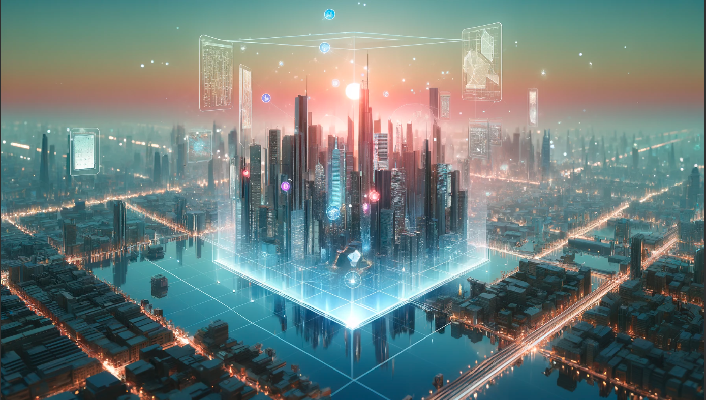
AI-Driven 3D Digital Twins and Virtual Realities: Revolutionizing Urban Planning
The integration of artificial intelligence (AI) into the development of 3D digital twins is revolutionizing geospatial technologies and urban planning. In this blog, I explore the advanced techniques and AI algorithms that are essential for achieving high accuracy, efficiency, and scalability in creating digital twins.
Key Technologies and Platforms
High-resolution 3D mapping of countries necessitates sophisticated platforms capable of managing large datasets and complex simulations. Technologies such as LiDAR (Light Detection and Ranging) and photogrammetry are crucial, often used together to capture detailed terrain and infrastructure data. AI significantly enhances these technologies by improving the speed and accuracy of data processing and feature recognition, which are pivotal for crafting highly accurate digital twins.
AI Algorithms in Action
AI is crucial in enhancing the accuracy and usability of 3D digital twins:
Machine Learning for Feature Detection
Algorithms Used:
Supervised classification algorithms like Support Vector Machines (SVM), Random Forests, and clustering algorithms such as K-means and DBSCAN are fundamental.
Process:
This involves data preprocessing, feature extraction, model training, and the classification of features such as roads, buildings, and natural landmarks. Raw satellite or aerial images are first preprocessed to correct for distortions and to normalize lighting conditions. Textural, spectral, and contextual features are then extracted from these images, for instance, edge detection algorithms might be used to outline structures.
Deep Learning for Image Processing
Algorithms Used:
Convolutional Neural Networks (CNNs) are critical for tasks such as image enhancement and stitching.
Generative Adversarial Networks (GANs) are used for generating high-resolution images from lower-quality inputs, crucial when high accuracy is necessary but the available imagery is of lower quality.
Process:
Includes data augmentation, model training, image reconstruction, and enhancement to ensure higher quality and seamless image stitching.
Techniques like deblurring and noise reduction are applied to enhance the clarity and quality of the images.
Predictive Analytics for Urban Planning
Algorithms Used:
Regression models and time series forecasting models like ARIMA and LSTM are utilized for predicting urban development patterns.
Process:
Involves collecting historical data on urban development, performing feature engineering, training models, and simulating different future scenarios.
This helps planners visualize potential outcomes and make informed decisions.

Creating 3D Digital Twins from 2D Satellite Images
The transformation of 2D satellite images into 3D digital twins involves several sophisticated steps that leverage both computer vision techniques and AI algorithms:
Data Collection
High-resolution 2D satellite images and street view photographs are gathered, covering the same areas from multiple angles to ensure depth and perspective can be accurately gauged.
Data Used: High-resolution 2D satellite images and street view photographs.
Image Processing
The collected images undergo processing to enhance quality and align them accurately, which might involve color correction, resolution enhancement, and geometric corrections to remove distortions.
AI Algorithms:
Image processing algorithms are used for color correction, resolution enhancement, and geometric corrections to align images accurately and remove distortions.
Feature Extraction
Using computer vision techniques, distinct features such as edges, corners, and unique landmarks are identified within the images, crucial for matching and aligning different images of the same objects or locations from various viewpoints.
AI Algorithms:
Convolutional Neural Networks (CNNs) are employed to detect and identify distinct features such as buildings, roads, and natural landscapes within the images. These are crucial for matching and aligning different images of the same objects or locations from various viewpoints.
Stereophotogrammetry
This technique involves using pairs of images taken from slightly different angles to create depth perception. By analyzing the differences between these image pairs, it’s possible to calculate the distance to various points in the photo, creating a depth map.
Data Used: Pairs of images from different angles.
AI Algorithms:
This technique uses depth-sensing algorithms to analyze the differences between pairs of images, creating a depth map by estimating the distance to various points in each photo.
3D Modeling
With depth maps constructed, algorithms begin building the 3D models. Points identified in the depth maps are converted into vertices in a 3D mesh.
AI Algorithms:
3D reconstruction algorithms convert points from depth maps into vertices in a 3D mesh, forming the basic structure of the digital twin.
Texture Mapping
High-resolution images are used to texture these models to give them a realistic appearance. The textures are wrapped around the 3D models based on how the images align with the mesh structure.
High-resolution images.
AI Algorithms:
Texture mapping algorithms wrap textures around the 3D models based on the images' alignment with the mesh structure.
Generative Adversarial Networks (GANs) might also be used to refine textures and improve detail for enhanced realism.
Refinement with AI
AI algorithms refine these models, predicting and filling in gaps in data, correcting errors in the mesh, or enhancing textures.
Data Used: Textured 3D models.
AI Algorithms:
AI refinement algorithms predict and fill in data gaps, correct errors in the mesh, or enhance textures to ensure the models are as accurate and realistic as possible.
Integration and Optimization
The final models are optimized for various uses, such as virtual reality simulations, urban planning tools, or video games.
Data Used: Refined 3D models.
AI Algorithms:
Optimization algorithms reduce the complexity of the models while retaining detailed textures and accurate geometries, ensuring the digital twins are optimized for various applications like virtual reality, urban planning tools, or video games.
Real-Time Rendering: 3D Gaussian Splatting

The world of 3D graphics is constantly evolving, and recent advancements in Radiance Field methods have taken visualization synthesis to new heights. But what if you crave real-time rendering without the hefty computational cost of training complex neural networks? Enter 3D Gaussian Splatting, a technique poised to revolutionize the way we render scenes in real time.
Gaussian Splatting isn't entirely new. Its roots trace back to the 90s in the scientific field. However, its recent application to real-time scene visualization, presented at SIGGRAPH 2023, has brought this powerful technique back into the spotlight.
Gaussians Backend
At its 3D Gaussian Splatting is a rasterization technique. Imagine a vast number of tiny particles (millions, to be exact) scattered throughout the 3D space. These aren't your average particles, though. Each one is a 3D Gaussian, defined by:
Position: Where it resides in the 3D world (X, Y, Z coordinates)
Covariance: How it stretches and scales (represented by a 3x3 matrix)
Color: Its RGB value
Alpha: It’s level of transparency
It is, therefore, analogous to triangle rasterization in computer graphics, which is used to draw many triangles on the screen. However, instead of drawing triangles, they are Gaussian. Therefore, it is described by the following parameters given above.


So, how does 3D Gaussian Splatting translate captured data into real-time visuals? The process involves several key steps:
Structure from Motion (SfM): We begin by using SfM, a technique that extracts a point cloud (a set of 3D points) from a collection of images. This point cloud serves as the foundation for our scene.
Converting to Gaussians: Each point in the cloud is transformed into a 3D Gaussian, laying the groundwork for rasterization.
Training the Splats: To achieve high-quality results, these Gaussians need some training. Here, a process similar to training neural networks (Stochastic Gradient Descent) comes into play.
Rendering the Scene: Once trained, the Gaussians are efficiently rendered onto the screen using a technique called "differentiable Gaussian rasterization." This involves projecting them from the camera's perspective, sorting them by depth, and meticulously combining them to create the final image.
3D Reconstruction Techniques Comparison
| Feature | NeRF | Gaussian Splatting | Drone Photogrammetry |
|---|---|---|---|
| Accuracy | Excels in capturing fine details and intricate spatial structures | Provides accurate visualizations, smooth transitions | Offers high measurement accuracy for real-world topography and structures |
| Computational Requirements | High computational resources for training and inference (limits real-time) | Careful parameter selection can impact real-time performance | Processing large drone datasets can be demanding |
| Flexibility | Adaptable to dynamic and non-rigid scenes | Versatile for integrating diverse data (may struggle with dynamic scenes) | Adaptable to various geospatial scenarios and environments |
| Strengths |
|
|
|
| Weaknesses |
|
May require parameter tuning for optimal results | Not ideal for capturing dynamic scenes |
| Data Input | Images | Images (can potentially use point clouds) | Drone captured images |
| Applications |
|
|
|
The Splatting advantage
Traditional photometry techniques, while useful for object scanning, struggle with scenes lacking clear contours or fine details. Additionally, they might falter when dealing with reflections or transparent elements.
NeRF (Neural Radiance Fields) emerged as a solution, offering superior rendering for open scenes and intricate surfaces. However, NeRF relies on powerful hardware for real-time rendering. Check our blog on the NeRF to learn more about it. 3D Gaussian Splatting presents a compelling alternative. While it utilizes machine learning for training, the actual rendering process is significantly faster, making real-time experiences a reality.
NeRF: Transforming Photos into 3D Scenes in Seconds
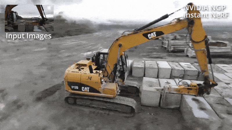
The NeRF 3D modeling system is a revolutionary approach that combines deep learning and computer vision techniques to generate highly detailed and realistic 3D models of objects and scenes. The system works by using a large set of 2D images taken from different viewpoints of the object or scene. These images are then fed into a neural network that learns to infer the 3D structure and appearance of the object or scene. The result is a high-fidelity 3D model that can be rendered from any viewpoint with astonishing realism.
Imagine capturing a realistic 3D scene from a handful of still images. That's the magic behind NeRF (Neural Radiance Fields). It leverages artificial intelligence to essentially reverse the process of photography, turning 2D photos into a digital 3D world.
How Does it Work?
Think of it as a highly detailed picture painter. Instead of using brushes and paint, it uses a neural network, a powerful computer program that learns from data. Here's the artistic process:
Data Collection: NeRF, like a photographer, needs a collection of images of the scene you want to capture in 3D. These images should be taken from various angles, similar to how you might walk around an object to get a complete picture. Importantly, the camera positions for each image also need to be recorded.
Filling in the Blanks: With its collection of 2D images, NeRF goes to work. It trains the neural network to essentially act like a scene sculptor. The network analyzes the light and color data from the images and learns how light interacts within the 3D space. It then uses this knowledge to predict the color of light radiating from any point in that 3D space. This allows NeRF to reconstruct the entire scene, even accounting for occlusions (when objects are hidden from certain viewpoints in the photos).
The NeRF 3D modeling system is incredibly useful in various fields such as computer graphics, virtual reality, augmented reality, and even in fields like archaeology and cultural heritage preservation. Its ability to accurately capture the intricate details of objects and scenes makes it an invaluable tool for creating realistic virtual environments, digital reconstructions of historical sites, and even for generating lifelike characters and objects in movies and video games. This 3D modeling system's innovative approach has significantly advanced the field of computer vision and deep learning. By leveraging a large set of 2D images from different perspectives, the neural network can accurately learn the intricate 3D structure and appearance of the object or scene. This capability has unlocked a wide array of applications across diverse industries.
Industries impacted
Autonomous cars use this to simulate and navigate real-world environments, allowing them to understand and react to their surroundings with a high level of precision. In the field of virtual reality, NeRF has enabled the creation of immersive, lifelike experiences by generating detailed 3D models that accurately represent the physical world. When applied to cultural heritage preservation, NeRF has been instrumental in digitally preserving and recreating historical artifacts and sites, providing a means to safeguard and share cultural heritage with future generations. The continued development and refinement of NeRF technology hold the promise of even more impactful applications in the future, with the potential to reshape industries and enhance our understanding and interaction with the physical world.
In the realm of computer graphics, NeRF has revolutionized the creation of virtual environments by enabling the generation of highly detailed 3D models with astonishing realism. The system's ability to capture subtle nuances and intricate details has elevated the quality of graphics in virtual reality and augmented reality experiences, providing users with immersive and lifelike digital environments.
In fields such as archaeology and cultural heritage preservation, the NeRF 3D modeling system has played a crucial role in digitally reconstructing historical sites and artifacts with unprecedented accuracy. This has not only facilitated the preservation of cultural heritage but also provided researchers and historians with powerful tools for studying and sharing these valuable resources. Furthermore, in the entertainment industry, NeRF has proven to be an indispensable tool for creating lifelike characters and objects in movies and video games. The system's ability to faithfully render the appearance and structure of objects from any viewpoint has significantly enhanced the visual quality and realism of digital content, offering audiences an unparalleled viewing experience.
The future of 3D capture likely lies in combining the strengths of NeRF and indoor mapping. Imagine using NeRF to add realistic lighting and textures to a highly detailed 3D point cloud generated by LiDAR. This could lead to the creation of incredibly realistic digital twins of indoor spaces, useful for architectural design, real estate visualization, facility management, and even indoor robot navigation.
- By Malcolm Parbhoo, Shikhar Jaiswal and Sameer Sankhe


